
Browse Items (5932 total)
Sort by:
Northwest -- Idaho -- Burke (#04)

"Gorge Gulch. Upper End of Burke down which all Hercules Ore was hauled; One team of horses would bring the load of ore down but it took 6 teams of draft horses to take the empty wagon back up. Looking up the canyon through Gorge Gulch and very…
Northwest -- Idaho -- Burke (#03)

"This mining camp as it appeared in 1887." Signs indicate the locations of the Poorman and Tiger Mines. Taken August 1887.

Northwest -- Idaho -- Burke (#01)

General view of the canyon and of the town at the time the Hecla mine was starting development.


Northwest -- Highways -- Washington (#12)

"Panoramic View of the highway grade leading down into that community from the hills."
Northwest -- Highways -- Washington (#11)

"Highway northward through the Grand Coulee, Washington, toward the north end of the Coulee"
Northwest -- Highways -- Washington (#11)

"Highway northward through the Grand Coulee, Washington, toward the north end of the Coulee."


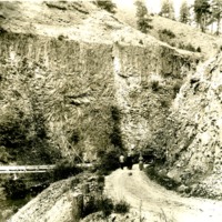
Northwest -- Highways -- Idaho (#07)

"The Serpentine highway (A 10-mile section) between Culdesac and Winchester, Idaho."
Northwest -- Highways -- Idaho (#02)

"Winchester grade near Winchester, Idaho. Now by-passed by better highway."

Northwest -- Geology -- Washington (#10)
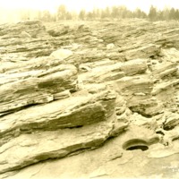
"Showing the Kettles holes in the bedrock worn by the cutting effect of the Columbia River current at Kettle Falls"


Northwest -- Geology -- Washington (#05)

"Glacial erosion;; action of the Spokane glaciation in the Upper Flathead Valley"
Northwest -- Geology -- Washington (#04)

"Glacial erosion action of Spokane glaciation in Upper Flathead Valley"
Northwest -- Forts and blockhouses -- Washington -- Fort Walla Walla (#24)

"Site of Ft. Walla Walla. Columbia River just below juncture of Walla Walla River and Columbia - showing 'Twin Sister' rocks."
Northwest -- Forts and blockhouses -- Washington -- Fort Walla Walla (#21)

"A view of the site and physical surroundings of the old HBC post as the locality appeared about 1921."
Northwest -- Forts and blockhouses -- Washington -- Fort Walla Walla (#20)

Two women and a boy at the site of Fort Walla Walla on the Columbia.