
Browse Items (5932 total)
Sort by:
Northwest -- Forts and blockhouses -- Washington -- Fort Spokane (#28)

"Fort Spokane, Lincoln County. Quartermaster stables building 1884. View N. E."
Northwest -- Forts and blockhouses -- Washington -- Fort Spokane (#40)

"Fort Spokane, Lincoln County. Restored guard house has a visitors center; view west. Erected 1892; remodeled by the National Park Service in 1966. Exterior appearance has been carefully retained. Interior has been modernized for today's use."

Northwest -- Forts and blockhouses -- Washington -- Fort Spokane (#44)

"Showing remains of the old post just above the mouth of the Spokane River"
Northwest -- Forts and blockhouses -- Washington -- Fort Spokane (#66)

Copy print of photo of Old Fort Spokane taken in the 1880s.
Ballard's Plannery Modern Bungalow.

The Ballard Plannery Company was an architectural firm in Spokane, which sold their plans. Many homes in Spokane were built using the plans between 1900 and 1920.
Ballard's Plannery [unknown plan book].

The Ballard Plannery Company was an architectural firm in Spokane, which sold their plans. Many homes in Spokane were built using the plans between 1900 and 1920.
Northwest -- Forts and blockhouses -- Washington -- Fort Walla Walla (#03)

"View showing the foundation of the old fort as they remain at the present day. Lines of rock show the old foundation outlines. Within these foundation lines stand two concrete boathouses."
Northwest -- Forts and blockhouses -- Washington -- Fort Walla Walla (#04)

"Site of old Fort Walla Walla. View of Columbia River looking upstream, below "Twin Sisters" rocks. Shows beginnings of tank farm at Attalia, est. by Kirk Thompson."
Northwest -- Forts and blockhouses -- Washington -- Fort Walla Walla (#05)

"Juncture of Walla Walla (clump of trees at left) and Columbia River where Fort Walla Walla was located."
Northwest -- Forts and blockhouses -- Washington -- Fort Walla Walla (#06)

"Looking south across the site of Fort Walla Walla fur trading post. Where present building stands."
Northwest -- Forts and blockhouses -- Washington -- Fort Walla Walla (#08)

Site of Fort Walla Walla on the Columbia River
Northwest -- Forts and blockhouses -- Washington -- Fort Walla Walla (#09)

Site of Fort Walla Walla on the Columbia River
Northwest -- Forts and blockhouses -- Washington -- Fort Walla Walla (#15)

"A view of the site and physical surroundings of the old HBC post as the locality appeared about 1921."
Northwest -- Forts and blockhouses -- Washington -- Fort Walla Walla (#16)

Site of Fort Walla Walla on the Columbia River
Northwest -- Forts and blockhouses -- Washington -- Fort Walla Walla (#17)

Site of Fort Walla Walla on the Columbia River
Northwest -- Forts and blockhouses -- Washington -- Fort Walla Walla (#18)

Site of Fort Walla Walla on the Columbia River
Northwest -- Forts and blockhouses -- Washington -- Fort Walla Walla (#20)

Two women and a boy at the site of Fort Walla Walla on the Columbia.
Northwest -- Forts and blockhouses -- Washington -- Fort Walla Walla (#21)

"A view of the site and physical surroundings of the old HBC post as the locality appeared about 1921."
Northwest -- Forts and blockhouses -- Washington -- Fort Walla Walla (#24)

"Site of Ft. Walla Walla. Columbia River just below juncture of Walla Walla River and Columbia - showing 'Twin Sister' rocks."
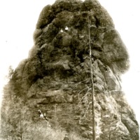
Northwest -- Geology -- Washington (#04)

"Glacial erosion action of Spokane glaciation in Upper Flathead Valley"
Northwest -- Geology -- Washington (#05)

"Glacial erosion;; action of the Spokane glaciation in the Upper Flathead Valley"


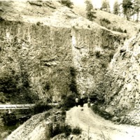
Northwest -- Geology -- Washington (#10)
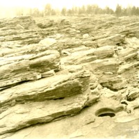
"Showing the Kettles holes in the bedrock worn by the cutting effect of the Columbia River current at Kettle Falls"
Northwest -- Highways -- Washington (#11)

"Highway northward through the Grand Coulee, Washington, toward the north end of the Coulee"

Northwest -- Idaho -- Burke (#05)

The night shift of the Tiger mine poses for a photograph. Date unknown.

Northwest -- Idaho -- Eagle City (#01)

"Matheny and Johnson Placer showing town of Eagle with a view of Pritchard Creek"
Northwest -- Idaho -- Elk River (#01)

Aerial view of Elk RIver, Idaho. Gold Creek in background. Taken before 1950.
Northwest -- Idaho -- Lapwai (#04)

"View of the town of Lapwai and Indian Agency buildings, the latter being in the foreground of the view"
Northwest -- Idaho -- Lewiston (#05)

The Luna House. Originally a hotel, the building served as the county courthouse from 1882 to 1889. The building was razed prior to January 1891.

Northwest -- Idaho -- Lewiston (#07)

"A checkerboard view of Lewiston (Idaho). Orchards, showing one of the two reservoirs serving the district."

Northwest -- Idaho -- Lewiston (#09)

"The biggest little city in the West, Lewiston, Idaho. Here we see the business section and get the excellent view of Normal Hill, the residential portion of the city."
Northwest -- Idaho -- Lewiston (#10)

"Clearwater Timber Company, now Potlatch Forest Industries. Lewiston, Idaho"