
Browse Items (5932 total)
Sort by:

Spokane -- Views (Folder 1, #16)

"View of the east end of the city across "Little Baldy" to Mt. Spokane in the far background."

Spokane -- Views (Folder 1, #14)

Looking north from South Hill. Howard St. in foreground running north.
Spokane -- Views (Folder 1, #13)

"Cloud bank October 24, 1936. Looking North from Lewis and Clark High School."


Spokane -- Views -- Aerial (#36)

Looking Southeast across the lower edge of Browne's Addition. Little Sunset Highway, Latah (Hangman) bridge in lower right.


Spokane -- Views -- Aerial (#20)

Taken north and west of downtown Spokane. Cement plant on Government Way visible in foreground. Natatorium Park visible across river to the left. Summit Blvd. located above the bluff. Cluster of buildings to the right of photo on Summit blvd. is St.…

Spokane -- Views -- Aerial (#09)

Buisness section of Spokane taken from above the Paulsen Building. Note Airport sign on Old Nat'l Bank bldg.

Spokane -- Views -- Aerial (#05)

View of High Bridge (Union Pacific Railroad bridge) crossing Latah Creek and the Spokane River. White building just above Monroe Street Bridge is Montgomery Wards store and later City Hall. Taken from point just west of town faceing east.
Spokane -- Views -- Aerial (#03)

Aerial View of the buisness district looking east. Taken two blocks west of the Davenport Hotel.


Spokane -- Views (Folder 1, #35)

Looking north from Cliff Drive. Streets visible are Wall and Howard.


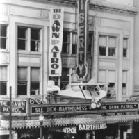
Spokane -- Theaters -- Orpheum (#01)

Orpheum Theater at night. The Orpheum was located at 118 N. Howard.
Spokane -- Telephone (#01)

"Long distance room in Spokane. I am first girl in white blouse at end of room (Beatrice Birmingham)"


Spokane -- Streets -- Riverside (#94)

Cars in front of Masonic Temple. Photo taken looking west on Riverside Ave.


Spokane -- Streets -- Riverside (#59)

Looking east along unpaved Riverside Ave. from corner of Stevens. ca. 1890