
Browse Items (5932 total)
Sort by:

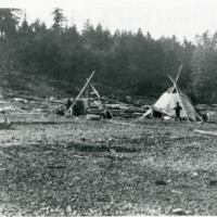
Indians -- Kalispel (#09)
"Kalispel Indian encampment on "Hawkins Point" at the mouth of Pack River, Lake Pend Oreille, now Bonner County, Idaho."
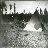
Indians -- Kalispel (#03)

"Kalispel Indian man on "Hawkins Point" on Lake Pend Oreille, west side of the mouth of Pack River, now Bonner County, Idaho."

Northwest -- Portraits -- Ballinger, Richard A., 1858-1922

Portrait of Richard Achilles Ballinger, mayor of Seattle, Washington, from 1904â1906, Commissioner of the General Land Office from 1907-1908 and U.S. Secretary of the Interior from 1909â1911.
Northwest -- Mines and mineral resources -- Alaska (#01)

A horse team takes the boiler (weight 1990 lbs) to the Pueblo Mine near Whitehorse, Yukon Territory, 1900.

Sunset from Shaw's Lodge on Diamond Lake, Newport, Washington
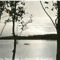
Sunset from Shaw's Lodge on Diamond Lake, Newport, Washington
Spokane Water Department "Maintenance Group"

Spokane Water Department "Maintenance Group" September 21, 1938.

Appleway Boulevard, Spokane Valley, Wash.
Appleway Boulevard, Spokane Valley, Wash. This photos used in 1914-1920 "good roads" campaign to show economy of good roads to farmer. First paved road in Spokane County.

Nicholas Cave Lindsay, son of Vachel and Elizabeth Conner Lindsay.

Nicholas Cave Lindsay, son of Vachel and Elizabeth Conner Lindsay.


Washington -- Parks -- Steamboat Rock State Park (#01)

"Grand Coulee, Steamboat Rock in distance. Now filled with Banks Lake"


Washington -- Grand Coulee (#01)

"Close-in of the granite rock formations at the head of the Coulee a short distance from the Columbia. Photograph by the Inland Automobile Association, Spokane."
Washington -- Hole-In-The-Ground (#09)

'Hole-in-the-Ground' between Rock and Bonnie Lakes south of Cheney, Washington
Washington -- Hole-In-The-Ground (#07)

"Chamber of Commerce tour to Hole-in-the-Ground between Bonnie and Rock Lakes south of Cheney, Washington"
Washington -- Hole-In-The-Ground (#06)

"Hole-in-the-Ground between Rock and Bonnie Lakes south of Cheney, Washington"
Washington -- Hole-In-The-Ground (#05)

"Natural bridge in 'Hole-in-the-Ground' between Rock and Bonnie Lakes south of Cheney, Washington"