
Browse Items (104 total)
- Collection: Spokane Views
Sort by:
Birdâs-eye view of the business section of Spokane

Birdâs eve view of the business section of Spokane. Some of the buildings are identified.

Spokane -- Spokane Falls (town) (#04)

Looking across the river and south. Note: "Medical Lake Soap Company" building in foreground.
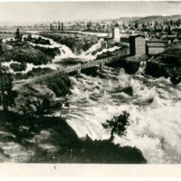
Spokane -- Spokane Falls (town) (#05)

The city of Spokane Falls in 1883 taken from Howard Street on the South Hill. Looking north.
Spokane -- Spokane Falls (town) (#12)

"View from the hill of Spokane, Washington. A. M. Cannon home in center front."
Spokane -- Spokane Falls (town) (#15)

Spokane Falls, Wash. Looking across the site now occupied by the Paulsen Building. Taken just before the fire in 1889.

Spokane -- Views (Folder 1, #35)

Looking north from Cliff Drive. Streets visible are Wall and Howard.


Spokane -- Views -- Aerial (#03)

Aerial View of the buisness district looking east. Taken two blocks west of the Davenport Hotel.
Spokane -- Views -- Aerial (#05)

View of High Bridge (Union Pacific Railroad bridge) crossing Latah Creek and the Spokane River. White building just above Monroe Street Bridge is Montgomery Wards store and later City Hall. Taken from point just west of town faceing east.

Spokane -- Views -- Aerial (#09)

Buisness section of Spokane taken from above the Paulsen Building. Note Airport sign on Old Nat'l Bank bldg.

Spokane -- Views -- Aerial (#20)

Taken north and west of downtown Spokane. Cement plant on Government Way visible in foreground. Natatorium Park visible across river to the left. Summit Blvd. located above the bluff. Cluster of buildings to the right of photo on Summit blvd. is St.…


Spokane -- Views -- Aerial (#36)

Looking Southeast across the lower edge of Browne's Addition. Little Sunset Highway, Latah (Hangman) bridge in lower right.


Spokane -- Views (Folder 1, #13)

"Cloud bank October 24, 1936. Looking North from Lewis and Clark High School."
Spokane -- Views (Folder 1, #14)

Looking north from South Hill. Howard St. in foreground running north.

Spokane -- Views (Folder 1, #16)

"View of the east end of the city across "Little Baldy" to Mt. Spokane in the far background."

Spokane -- Views (Folder 1, #22)

"Night view of the business section looking north. Taken from about the 600 block on West Cliff avenue, 9 p.m." (undated)
Spokane -- Views (Folder 1, #23)

"Northeast across the city in the Hillyard direction looking from the rim of the South Hill in 1925."


