
Browse Items (104 total)
- Collection: Spokane Views
Sort by:


Spokane -- Views (Folder 1, #38)

Looking north across the business section of the city from intersection of 5th and Adams.
Spokane -- Views (Folder 3, #07)

Looking north and slightly east from junction of Washington and Cliff.
Spokane -- Views (Folder 1, #13)

"Cloud bank October 24, 1936. Looking North from Lewis and Clark High School."
Spokane -- Views (Folder 1, #37)

"Looking north and east from Cliff Drive above the Finucane home on 8th and Washington."

Spokane -- Views (Folder 1, #40)

"Looking across the business section of the city from between 2 pines. Near 6th and Jefferson. Looking northeast."
Spokane -- Views (Folder 2, #26)

Cloud bank of Saturday afternoon, October 24, 1936. Looking west from Lewis and Clark High School.

Spokane -- Views (Folder 3, #01)

Looking from Cliff Drive at junction of Washington and Cliff between two tall pines with Paulsen Medical and Dental and Old National Bank buildings as chief motif in the scene.
Spokane -- Views (Folder 3, #35)

"Spokane as seen under the cloud mantle of the past Saturday afternoon, October 24th." Taken from Lewis and Clark High School.
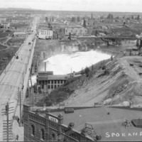
Spokane -- Views -- Aerial (#36)

Looking Southeast across the lower edge of Browne's Addition. Little Sunset Highway, Latah (Hangman) bridge in lower right.


Spokane -- Views -- Aerial (#03)

Aerial View of the buisness district looking east. Taken two blocks west of the Davenport Hotel.

Spokane -- Views (Folder 1, #14)

Looking north from South Hill. Howard St. in foreground running north.

Spokane -- Views (Folder 1, #35)

Looking north from Cliff Drive. Streets visible are Wall and Howard.


Spokane -- Views (Folder 2, #10)

View of buildings on the Spokane River. Clock tower in the background.


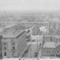
Spokane -- Views (Folder 2, #43)

Monroe street bridge and business district. Taken facing south and a little east.

