
Browse Items (89 total)
- Collection: Northwest Transportation
Sort by:

Northwest -- Roads and Trails (#16)
"Wallace - Kellogg - Mullan Road east of Cataldo Mission, 1926."
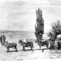
Northwest -- Stagecoaches (#03)
"First stagecoach made trips between Fort Colville and Spokane. Photo taken near library - Carnegie Library at Cedar St."
Northwest -- Pack Trains (#02)
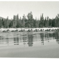
"Donahue photo. Summer 1940. Pack train crossing entrance to thoroughfare on Priest Lake."


Northwest -- Mullan Road (#13)

"Cobblestone pyramid marker used along the line of the road through Washington."
Northwest -- Mullan Road (#11)

"Mullan summit near tree showing Mullan Monument." "Trail marker at the summit of the 4th of July Canyon."


Northwest -- Highways -- Idaho (#02)

"Winchester grade near Winchester, Idaho. Now by-passed by better highway."

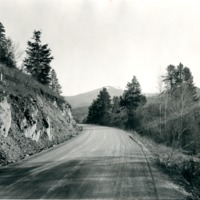
Northwest -- Highways -- Idaho (#07)

"The Serpentine highway (A 10-mile section) between Culdesac and Winchester, Idaho."
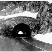
Northwest -- Highways -- Washington (#11)

"Highway northward through the Grand Coulee, Washington, toward the north end of the Coulee."


Northwest -- Highways -- Washington (#12)

"Panoramic View of the highway grade leading down into that community from the hills."


Northwest -- Steamboats (#02)

"Four of the old steamers which made the historic trip down the Columbia in May 1915 to celebrate the opening of the Celilo Canal are shown tied up at the Kennewick boat landing. The boats carried hundreds of joyous celebrants and public officials in…

Northwest -- Steamboats (#05)

"Steamer 'Spokane' about 1907. Ran between Newport and Ione, Washington."
Spokane -- Pigeon Hole Parking (#03)

"Men in photo: top, Arthur F. Schwartz, lift operator. Bottom: Henry Vorlicky, co-owner & manager."
Spokane -- Pigeon Hole Parking (#01)

"Pigeon Hole Parking Service at N. 22 Madison Street. Looking west at Our Lady of Lourdes Cathedral."
Spokane -- Pigeon Hole Parking (#04)

"Pigeon Hole Parking Service at N. 22 Madison. Looking northeast."

Northwest -- Bridges, Covered (#18)

"Monroe Covered R. R. bridge. View North from Milwaukee Line. Trestle across Skykomish River. Only 30 mi. driving time from Seattle. Another century."
Northwest -- Bridges, Covered (#08)

"Willapa; Pacific Co. Wilson Creek. Where cows are the principal users a covered bridge is sort of a barn in a storm. View N. W."
Northwest -- Bridges, Covered (#02)

"Schafer Bridge; built 1966. Owner: Carl A. Schafer, Montesano, Grays Harbor County. Location: Carl A. Schafer farm 5 miles N. E."

Northwest -- Bridges -- Tacoma Narrows (#01)

"Tacoma Narrows Bridge. View West. One of the World's Big Suspension Bridges. Second Bridge."
