
Browse Items (569 total)
- Collection: Scenic Northwest
Sort by:
Washington -- Grand Coulee (#11)

"Lover's Lane, the improved highway as it makes its way through the granitic formation near the north end of the Coulee"
Washington -- Grand Coulee (#12)

North end of the Grand Coulee. The highway and the high basaltic rock walls of the east line of the coulee near the north end.


Washington -- Grand Coulee (#24)

"North end, Grand Coulee, Wash. The granitic rock formations near the north end of the Coulee as viewed from the highway some distance to the south."
Washington -- Grand Coulee (#25)

"Grand Coulee, Wash. View of the strangely weathered rock formations of the lower coulee."


Washington -- Grand Coulee (#43)

"Peculiarly twisted basaltic formations in the walls of the coulee. Aerial view of the Dry Falls of the Grand Coulee, Washington"

Washington -- Parks (#02)

"Rock profile near Wenatchee, Washington assumed to bear a resemblance to the profile of Abraham Lincoln"


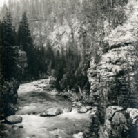
Northwest -- Rivers -- Wenatchee (#01)

"The thickly forested closed in gorge of the river near the headwaters of the stream"

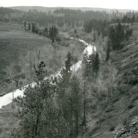
Northwest -- Rivers -- Wenatchee (#02)
"Looking up the river and through the thickly timbered gorge canyon of the stream"

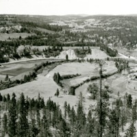
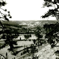
Washington -- Wenatchee River Valley (#01)

"Looking from a rocky height down into the valley of the Columbia below Wenatchee city across the orchards"
Washington -- Marcus Flats (#01)

"Looking across the flats in May 1940 from the south and a little to the east of the site of the old St. Paul's Mission."
Washington -- Marcus Flats (#02)

"Looking across the flats from a point to the east of the old St. Paul's Mission during the latter days of May 1940"
Northwest -- Creeks -- Latah Creek (Hangman Creek) (#03)

"Latah" is a Nez Perce name meaning "fish." Also known as "Hangman Creek."
Northwest -- Creeks -- Latah Creek (Hangman Creek) (#07)
"Looking down the course of the creek from the rim rock on the north bank at the site of the old Indian burial ground east from Spangle."
Northwest -- Creeks -- Latah Creek (Hangman Creek) (#08)
"Looking down upon the curve which is just to the east of the point where Marshall Canyon joins the Hangman Valley"
Northwest -- Creeks -- Latah Creek (Hangman Creek) (#09)

"Canyon above Smythe's Ford showing the meeting of the lava flows with typical Palouse region. Looking southwest up the course of the creek."
Northwest -- Creeks -- Latah Creek (Hangman Creek) (#10)

"View of the garden plots in the valley from the High Drive Parkway immediately above."
Spokane County -- Hangman Valley (#01)

"Looking southward up Hangman Valley and across the Stafford Addition from the end of 9th Avenue"
Spokane County -- Hangman Valley (#02)

"Looking northward down the valley and across the Sixth Avenue bridge from the High Drive parkway near the Washington Water Power Company's substation."
Spokane County -- Hangman Valley (#03)

"Looking northward down the valley from between two large pine trees and from near the Washington Water Power Company substation at 27th Avenue."
Spokane County -- Hangman Valley (#04)

"Looking southward up the valley from High Drive parkway. To the left is Browne's Butte. Inland Empire Highway follows valley"
Spokane County -- Marshall Canyon (#01)
"Looking southwestward up the canyon from High Drive, Spokane."
Northwest -- Canyons -- Deep Creek (#02)

"Viewed from east rim of Deep Creek Canyon about 3PM, March 28, 1937"


Northwest -- Canyons -- Deep Creek (#13)

"Example of differential weathering along the banks of the Spokane just east of the mouth of the Canyon"
Northwest -- Canyons -- Deep Creek (#14)

"One of the rock pinnacles showing effect of differential weathering within the mid section of the canyon."
Northwest -- Canyons -- Deep Creek (#17)

"Cheese-box like formation at foot of canyon and rising from east rim."